Mission Statement: To trace and document the European and other non-Aboriginal exploration of the North and the region's subsequent development.
While acknowledging the indigenous exploration of the land the First Peoples occupied, one also acknowledges the fact that they left no documentary record capable of being woven into a conventional history.
Such matters are best dealt with in the On the Surface: The Human Landscape section of Origins, Indigenes and Antecedents.
Here, the focus is on the Chinese, Portuguese, Dutch, Spanish, English, French and Australian exploration of the area, with an intention to provide a detailed account of the process by which the detail of contemporary maps of the region was established.
Prelude: Towards an Outline sets the expeditions that eventually delivered an almost-complete outline of the Northern coastline in the broader context of world exploration. That carries the story as fat as the arrival of the First Fleet in 1788.
Five Voyages delivers as much detail as I have managed to garner concerning the voyages of Torres and Jansz (1606), Carstensz (1624), Tasman (1644) and Cook (1770).
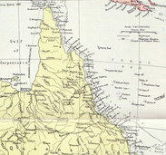
Adding Detail covers the period between 1788 and the separation of Queensland from New South Wales in 1859. At that point, the detailed exploration of The North became a priority for the fledgeling colonial government. At that point, while the outline was complete, most of the map was still blank, at least as far as the Migaloo were concerned.
Northern Queensland will take the narrative on from around the time the town of Bowen was established in 1861 through to Federation and beyond.
A funal volume, assuming we get that far, will carry the narrative through to the age of GPS and Google Maps.