The second issue regarded the route that would take us to New Norfolk and from there to our accommodation. Under normal circumstances, I'd have set up the iPad as a navigational aid, but in WiFi mode that's only good for one trip. I'd already set things up to get us from the Airport to Richmond, so we needed an alternative source of information. We found it at the Tourist Information department at Old Hobart Town, and if I'd looked more closely I'd have spotted the Free WiFi sign, which would have given us an iPad backup to the mud map we were given.
The mud map was clear enough. Turn right just out of town onto one of the Tea Tree Roads, follow it until the turn-off to Pontville and once you're there follow the highway through Brighton and Bridgetown and across the river to Granton. From there it's plain sailing to New Norfolk.
And it should have been plain sailing, even after we missed the turnoff to Pontville. The secret here is that we needed to hit the highway that whooshed you through to Bridgetown and across the river. Having arrived at Brighton, we weren't on it, and set about trying to find a road that would take us to a seemingly non-existent Bridgetown, which didn't appear on any traffic signs. The nearest thing we found was something called the Brighton-Bridgetown Transport Hub, and we were just about to head back to Brighton or somewhere to ask for directions when the penny finally dropped.
 We needed to get across the river. Hobart is on the other side of the river. Or much of it, anyway. Glenorchy is on the other side of the river. New Norfolk is on the other side of the river, and it's on the same side of the river as Hobart and Glenorchy.
Look at it that way and there’s a simple solution.
Follow the signs pointing us to Hobart and Glenorchy, cross the river, and look for an exit that would get us to New Norfolk. Easy. Why didn't I think of it earlier?
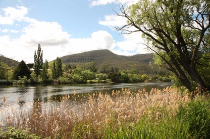
Once we were on the right road it was easy to forget recent frustrations due to the sheer magnificence of the Derwent estuary, particularly when you consider how far we were from the mouth.
According to the ubiquitous Wikipedia, the estuary stretches 52 kilometres from New Norfolk down past Hobart, creating what is often claimed to be the deepest sheltered harbour in the Southern Hemisphere. There are points along that fifty-kilometre stretch where the river is nearly three kilometres wide, and the salt water persists almost as far upstream as the fourth crossing point at New Norfolk Bridge.