

Day Three Tolga - Lakeland
And this, folks is where the adventure begins.
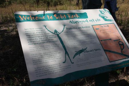
As previously indicated, I'd been in touch with the Quinkan Cultural Centre to see what the go was as far as guided tours of rock art sites were concerned, and had been informed that the only one accessible at the moment was Split Rock but I should call back the day before we arrived in case there were any developments in the meantime.
Now, we should have made that call while we were down on the coast and in range of the Virgin Mobile network, but that detail had slipped by in the pursuit of pie shops in towns which might have names starting with W, and we were walking out of the Rainforest Canopy Walk when Madam asked whether I thought I should ring.
Well, it was fairly obvious that I should, but in the car park at Mamu there wasn't a signal, so we figured it'd be better if we waited till we were close to a slightly larger centre (Atherton, for example) but by the time we were there Mickey's big hand was getting awfully adjacent to the twelve with the little hand hovering just before five, so I reckoned it wasn't worth trying.
Better, I thought, to call from a pay phone somewhere en route in the morning. The Palmer River Roadhouse seemed like an obvious choice since it would be easy for people on the other end of the line to calculate a likely arrival time. More on that matter anon.
The first consideration on the day, however, was breakfast. Something at the motel or get on the road and grab something along the way? No brainier. We had the car packed after a good night's sleep and we were pulling out of the car park at the motel just before eight.
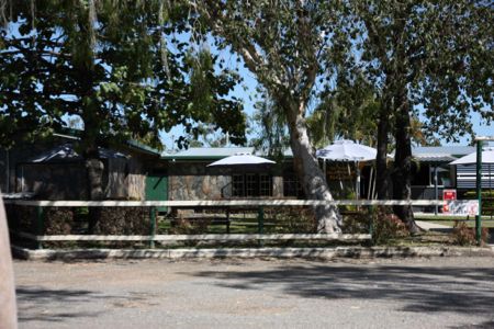
Any decent sized town is likely to have a bakery, and Tolga, according to the phone book, was no exception to the rule. About two blocks down from the motel was a cafe, and we turned into the side street to investigate and, in the process discovered the bakery lurking just behind the cafe.
Fine. Next question. Sit down in the cafe or grab something from the bakery? Anyone who assumes we were looking at whatever would get us to Laura ASAP was the go would be right on the money, and mini pizzas from the bakery did the job. The result was that we were out of Tolga by eight ten or thereabouts, with the next issue being the question of fuelling up. Mareeba seemed the logical choice, so I settled back for the brief sojourn through Walkamin, pointing out the distillery as a possible stop on the return journey.
Now, at this point, there are probably alert readers rolling their eyes at what may be seen as an obsession with alcohol-related venues, but I'd counter the eye-rolling with the observation that we'd end up going where the driver wants to go, so I mention possibilities without expecting too much in the way of eventualities in circumstances like this one.
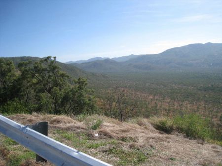
Past Mareeba it was obvious were we're getting away from the high rainfall belt.
Actually it was obvious before we left Mareeba, but there were large irrigation channels streaming water from Lake Tinaroo to crops of bananas, mangoes, sugar cane and assorted other agricultural produce between Atherton and Mareeba, but they gradually receded into memory once we were well on the Mulligan Highway.
The run up through Mount Molly and Mount Carbine was uneventful enough, with a quick scan of the horizon as we sailed through each township in case there was a pay-phone in view, but given the relatively early hour I wasn't inclined to look too closely. The Palmer River Roadhouse was, as previously indicated, probably the best option.
Scanning the horizon for pay phones was, in addition, less absorbing than watching the terrain and visualising would-be miners, bullock wagons and teams of pack horses battling their way up hill and down dale en route to the various mining discoveries in the hinterland.
Those thoughts were largely prompted after I noted the road down to Mossman that branched off the Mulligan just after Mount Molloy. Madam informed me that at one point, very early in proceedings, before she'd decided to spend a couple of days on the Tablelands, she'd briefly harboured thoughts of using that road to get us back to Cairns.
I'm not sure whether the road actually follows the notorious track that required double teams of bullocks to get wagons over a particularly nasty pinch called, if I remember correctly, The Bump, in that understated way we have of describing significant obstacles.
In any case I seem to recall stories of a very steep descent, and I wasted no time in assuring her that if the subject had been broached I would have been suggesting a look at the alternatives.
Musings on nineteenth century diggers doing it tough in a landscape that brooded with what Fred Dagg once termed the stark hostility of the very land itself gave way to thoughts of an ancient landscape, brooding with, not quite malevolence, more a sense of indifference. It's the same feeling I had crossing the Nullarbor, a feeling that the landscape knows you're there but has no concern whatsoever about another minor interruption. It was there long before you arrived and will be there millennia after you're gone.
Those feelings reached their peak when we stopped at Bob’s Lookout as the Mulligan weaved it's way around the end of the Desailly Range and after that the musings turned to the geology of the goldfields. There must have been reefs of gold in the ancient landscape (the original one millions of years back). Miners on the Palmer turned their attention to reefs once the alluvial started to run out, and I guessed those reefs were old, deep seated remnants of long gone veins of quartz-laden ore.
Gold, given its weight, won’t travel far when carried by water, so while the rest of long gone landscapes eroded, whatever gold reached the surface (and remember, this is all guesswork, Hughesy's geological knowledge doesn't extend much beyond the geomorphology component of Geography I in 1969 and the recent Time Traveller's Guide to Australia) wouldn't have gone far. Not in the first instance, anyway. But over the years the grains would have gradually been carried downwards, a little at a time, collecting behind whatever barrier impeded the flow of water, and creating the pockets of alluvial that gave rise to the label The River of Gold.
We broke the journey at the Palmer River Roadhouse, where the phone call established that, yes, there was a guide available, and that he was booked to do a tour of Split Rock with a party on a tour bus, and when he'd finished with them he'd look after us provided we could give him a lift back into Laura. The cost would be eighty dollars a head, not exactly cheap, but I figured it was better to have some idea what we were looking at and, presumably, he'd get us to places we wouldn't find ourselves.
The rest of the instructions were vaguer than some in the party would have liked.
Drive into the car park at Split Rock, I was told. If there's an Outback Spirit bus in the car park, he's up in the gallery with the tour. If you get there after the tour has gone I'll get him to wait at the kiosk.
Lack of clarification about driving conditions didn't please the driver, but I reckoned the bloke on the other end on the line probably knew what he was doing. If his guide was going to get back we needed to get there, so presumably there was nothing to prevent us from doing that.
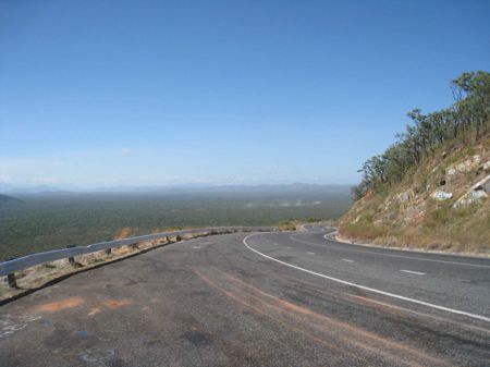
From the Road House there's a rapid descent of the Byerstown range, Byerstown (long since gone) being the easternmost settlement on the Palmer and then we were in the wide river valley that takes you, first, to Lakeland Downs, and then, after a left hand turn, towards Laura.
There are huge swathes of broad acre farming around Lakeland, and the ranges are a relatively distant prospect on the left and right. Somewhere in there over on the left was the legendary Hells Gate, a narrow gap in the escarpment, three days' walk without water, a place so narrow that buckles on the saddles of passing teams of pack horses left scrape marks on the rock.
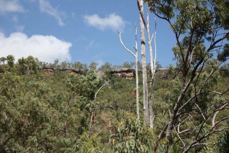
The ranges on either side narrowed as we neared Laura, and we started to spot formations just under the ridge line that certainly looked, to a novice's eyes, like the sort of place where you might find shelter during the wet season. Shortly thereafter a signpost pointed us towards the Split Rock car park, just off the bitumen highway.
So we were there, but there was no sign of a tour bus.
Proceeding according to instructions I wandered over to the kiosk, found it deserted, wandered back past a parked car that had no sign of any occupants, and headed back to the remaining vehicle, where a bloke in an Outdoor Education Centre T-shirt was in the process of negotiating a cup of coffee with the Missus.
I was still figuring out what to do and ascertaining this couple's intentions when, lo and behold, a tour bus and trailer pulled in of the highway and pulled up behind the previously noted unoccupied vehicle.
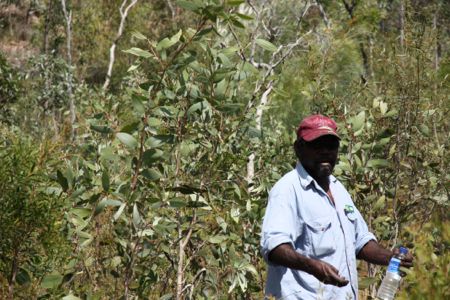
It was an obvious case of heading in that direction, and I arrived to find the bus disgorging its occupants while a nuggety Aboriginal bloke in faded blue shirt and denim jeans was looking in my direction.
Roy? Ian? And a handshake concluded the introductions, I quickly ascertained we were to tag along with the tour group, so I headed back to impart news, apply sunscreen, collect bottled water and get my stuff together. Roy, I noted, was carrying a water bottle, confirming my suspicions that I'd be needing two.
By the time we reached the tour group, the bus had totally disgorged its elderly occupants, and from a look at the gathering it was obvious we weren't going to be doing anything over strenuous.
As we set off we found ourselves at the end of what used to be termed, in English schoolboy stories, a crocodile, though given the issues associated with fitness and agility with this party, one was certainly hoping the saurians were thin on the ground up in these parts well away from the water.
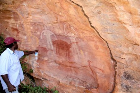
The climb wasn't quite as straightforward as one might have presumed, and there were frequent stops that served the dual purpose of giving Roy a chance to talk about bush tucker or point out something of botanical interest and giving less agile members of the party a chance to catch up.
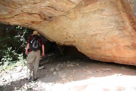
There were a couple of smaller galleries on the way up, faded by weather and partly obscured, as Roy explained, by dust from the previously unsealed road but arriving at the actual Split Rock gallery we found ourselves on a large wooden platform with seating on the outer rim.
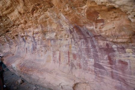
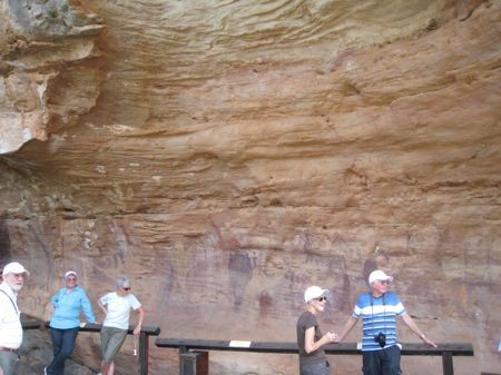
There was plenty to see, with paintings superimposed over others, all fading under the influences of dust and weather, but all placed in the invidious position where trying to do anything approximating restoration would probably do more harm than good.
There was a lengthy pause there as Roy talked to whoever wanted to talk to him, and I waited until those conversations were breaking up before crossing to check whether we were supposed to be taking him back to Laura. From conversations along the way I gathered the tour bus had come up from Cooktown via Battle Camp, and would presumably be heading of to the Tablelands or Mossman, so our presence would save the driver going back to drop the guide in Laura.
The inquiry produced the news that, yes, we were to drop him back at base, and that once the tour party had left he'd take us over the top, though the top remained an undefined concept.
With the tour party heading back to their bus, we headed further up the slope to some smaller sites, passing a couple of itinerant sightseers on the way, and reached a one where the track was, well, not quite barred, but a sign indicated that unauthorised persons should not proceed beyond this point.
As we proceeded to ignore the instructions one assumed we were now authorised, and I learned that the sign was there because the trail hadn't been cleared or prepared after the end of the wet season.
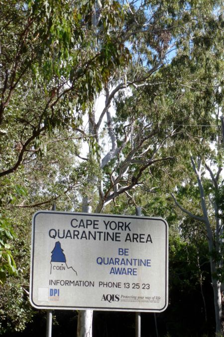
This, from what I can gather, is the issue with the rest of the sites. Unlike Split Rock, they're only accessible by four wheel drive, and that means getting people out on the tracks to make sure the vehicles can get to where they're supposed to go. The sites are on the Split Rock side of the Laura River, so the first issue after the wet season has finished is to wait until the river goes down. Split Rock might be easily accessible from the sealed highway, but until they've finished the high level bridge it's inaccessible from Laura, and the tours had only resumed the previous week.

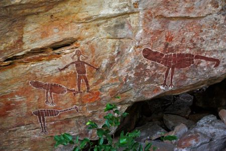
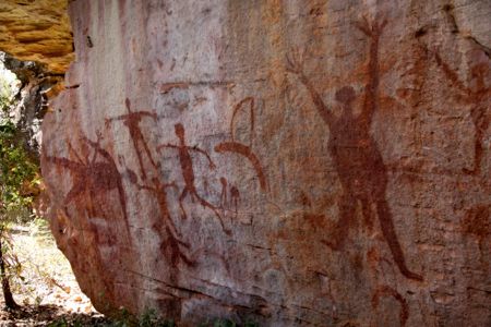
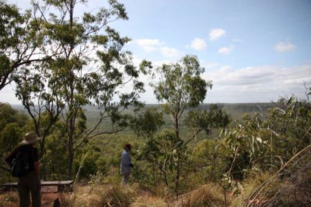
All that explained the fairly rough going as we made our way up the escarpment, across the plateau on the top, over to Turtle Rock, a spectacular lookout over the Palmer country, and back down through the Gugu Yalanji galleries, the last of which were quite spectacular, being nestled in a position that was more sheltered from dust, wind and water and relatively inaccessible. The National Parks and Wildlife Rangers had apparently been around the area fairly recently, but it seemed we were the first outsiders to visit this particular area this year.
From there we had a lengthy and occasionally hairy descent, joining the Split Rock track and making our way back to the car park just after three o'clock.
Given the fact that we'd arrived there around eleven-fifteen (I was too busy scanning the horizon for tour buses to note precise times) and allowing for speed of travel considerations with the tour party, that amounted to a three hour guided walk which seemed pretty fair value at eighty dollars per head.
Heading back to Laura we turned off the bitumen onto a dirt detour just before the new and still unfinished bridge, with Roy explaining that it could be three or four months once the river rose above the old low level right down there In the river bed bridge, and for that time it was a case of flying in food supplies.
Those issues raised themselves again at the Quinkan Cultural Centre, where the bloke I'd spoken with over the phone elaborated on the new bridge and the likely benefits of year round access to Split Rock from the Laura side.
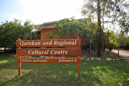
He also let slip the (well, to me, anyway) surprising news that until he'd taken over at the Centre, tours to the rock art galleries had been led by non-indigenous guides, something that I found quite incredible.
In any case, the really spectacular galleries, including Giant Horse, the one I really wanted to see, are only accessible through the Quinkan Centre, but I'd still suggest, assuming you're fit and interested, that you take the guided Split Rock tour (I'm assuming that's more or less what we got) rather than just lobbing in the car park and wandering up the hill to take a gander at the paintings.
In any case, if you are there and decide not to do anything extravagant you should definitely drop the suggested $5 per head in the honesty box at Split Rock and take a good look at the displays at the Quinkan Centre, where you can also make the donation. Depends on which way and how far you're going.
A more detailed account of this bit of the trip would have required the use of a notebook or voice recorder, and, to be quite honest, I was too busy keeping up with the walk to be stopping to scribble, and vocal records would have come with a good deal of puffing and panting.
Still, I have to say those three hours were one of the most memorable experiences I've had, and did a lot to clarify my thinking about long dormant historical research. Whether anything concrete comes out of that renewed interest remains to be seen (he said, tapping out his impressions in a motel room at Lakeland Downs the following morning).
From the Quinkan Centre it was off to the pub for a quick chilled article, then back to Lakeland Downs for the night. In retrospect it might have been possible to head all the way into Cooktown, but three hours clambering over the escarpment meant that by the time we'd checked in, had a short rest, and demolished a couple of seafood baskets we were both pushing up the Zs shortly after seven thirty.